Description:
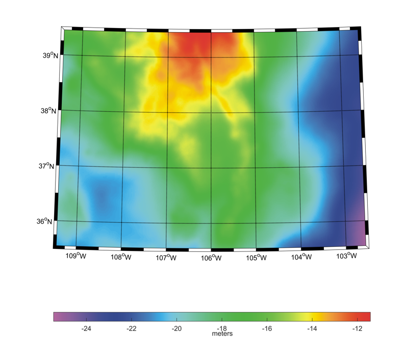
The ColSCA-CASM2019 gravimetric quasi-geoid and geoid models have been computed by the Chinese Academy of Surveying and Mapping. They have been worked out in the frame of the International Association of Geodesy Joint Working Group 2.2.2 "The 1 cm geoid experiment" and the so called "Colorado experiment". The area covered by the models is 109.5°W ≤ longitude ≤ 102.5°W, 35.5°N ≤ latitude ≤ 39.5°N with a grid spacing of 1' in both latitude and in longitude. The height anomaly computation from the satellite gravity model GOCO05S, terrestrial and airborne gravity data is based on the spectral combination approach. Spectral weights of each dataset are determined by using the KTH error degree variance estimation method. A remove-compute-restore procedure, based on the EGM2008 global gravity model, is applied to account for the contribution outside local gravity data coverage. A residual terrain correction is computed from the SRTM model to consider the short wavelength components of gravity field generated by the high frequency part of topography. Height anomalies are converted to geoid undulations by using the refined Bouguer anomalies and the gradient of the gravitational potential (Flury and Rummel, 2009). The accuracy of the quasi-geoid and geoid models, when compared against GSVS17 GPS/leveling, is equal to 3.1 cm and 3.5 cm, respectively.
Model Citations:
T. Jiang (2019). The CASM quasi-geoid based on spectral combination approach for the Colorado Experiment: ColSCA-CASM2019. V. 1.0. GFZ Data Services. DOI: 10.5880/isg.2019.009
T. Jiang (2019). The CASM geoid based on spectral combination approach for the Colorado Experiment: ColSCA-CASM2019. V. 1.0. GFZ Data Services. DOI: 10.5880/isg.2019.010
References:
T. Jiang (2019). README file for the Colorado 1 cm geoid experiment. Report of the Joint Working Group 2.2.2 "The 1 cm geoid experiment", pp.1-5.
T. Jiang, Y. Dang, C. Zhang (2020). Gravimetric geoid modeling from the combination of satellite gravity model, terrestrial and airborne gravity data: a case study in the mountainous area, Colorado. Earth Planets Space 72, 189. DOI: 10.1186/s40623-020-01287-y
T. Jiang, Y.M. Wang (2016). On the spectral combination of satellite gravity model, terrestrial and airborne gravity data for local gravimetric geoid computation. Journal of Geodesy 90, pp. 1405-1418. DOI: 10.1007/s00190-016-0932-7
J. Flury and R. Rummel (2009). On the geoid–quasigeoid separation in mountain areas. Journal of Geodesy 83, pp. 829-847. DOI: 10.1007/s00190-009-0302-9
Web of Science ID:
DRCI:DATA2023050026130139
Digital object identifier:
DOI: 10.5880/isg.2019.009 (quasi-geoid in ISG format)
DOI: 10.5880/isg.2019.010
(geoid in ISG format)
|