Colorado - USA (ColLSMSA-GEOF2019)
|
Authors: M. Varga, et al.
|
Created: 2020
|
Resp: M. Varga |
Description:
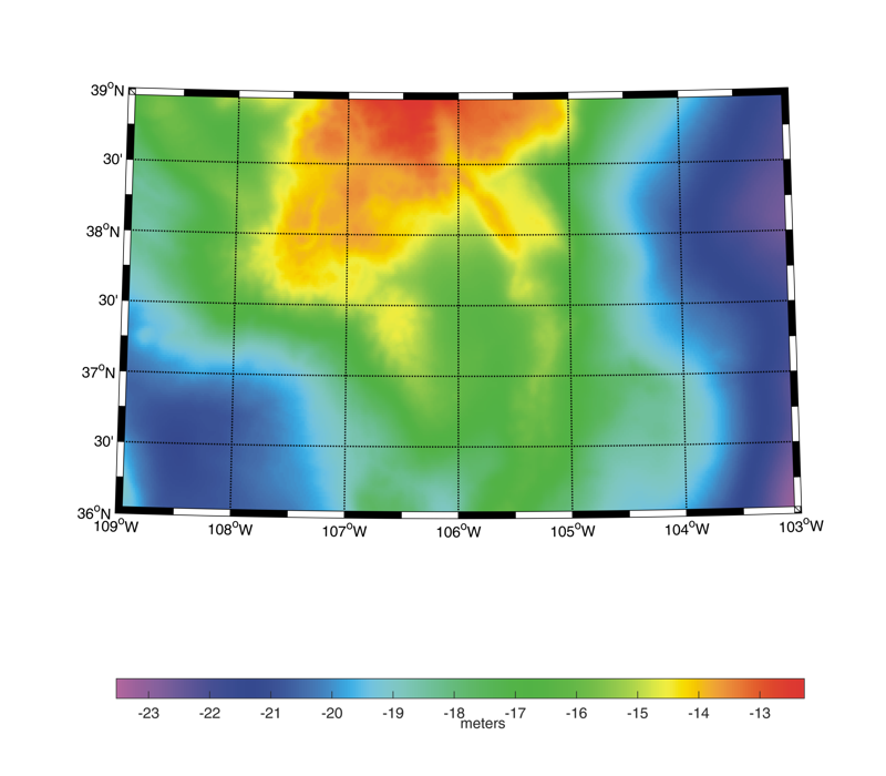
The ColLSMSA-GEOF2019 gravimetric quasi-geoid and geoid models have been computed by the Faculty of Geodesy, University of Zagreb (GEOF) in cooperation with the New technologies for the Information Society, University of West Bohemia (NTIS). They have been worked out in the frame of the International Association of Geodesy Joint Working Group 2.2.2 "The 1 cm geoid experiment" and the so called "Colorado experiment". The area covered by the models is 251°E ≤ longitude ≤ 257°E, 36°N ≤ latitude ≤ 39°N with a grid spacing of 1' in both latitude and in longitude. The geoid is computed using a two-step procedure. First, the terrestrial and airborne gravity data are gridded by Least Squares Collocation (LSC) with a planar logarithmic covariance model in the framework of a remove-compute-restore procedure. Long wavelengths are modelled by XGM2016 up to degree and order 500, while short wavelengths are taken from the topographic gravity effect. In the second step, the resulting 1'x1' grid of Molodensky-type free-air gravity anomalies is used to compute geoidal heights by using Least Squares Modification of Stokes’ formula with Additive corrections (LSMSA). In particular, the geoidal heights are obtained by using a biased modification of the Stokes kernel (0.5° spherical cap size integration) and then by adding four corrections, namely topographic, downward continuation, atmospheric and ellipsoidal corrections. Finally, the conversion from geoid to quasi-geoid is computed only approximately using the formula by Heiskanen and Moritz (1967). The accuracy of the quasi-geoid and geoid models, when compared against GSVS17 GPS/leveling, is equal to 3.6 cm and 3.9 cm, respectively.
Model Citations:
J. Ågren (2019). The GEOF-NTIS quasi-geoid based on Least Squares modification of Stokes integral with additive corrections for the Colorado Experiment: ColLSMSA-GEOF2019. V. 1.0. GFZ Data Services. DOI: 10.5880/isg.2019.005
J. Ågren (2019). The GEOF-NTIS geoid based on Least Squares modification of Stokes integral with additive corrections for the Colorado Experiment: ColLSMSA-GEOF2019. V. 1.0. GFZ Data Services. DOI: 10.5880/isg.2019.006
Reference:
M. Varga, M. Pitoňák, P. Novák, T. Bašić (2021). Contribution of GRAV-D airborne gravity to improvement of regional gravimetric geoid modelling in Colorado, USA. Journal of Geodesy 95, 53. DOI: 10.1007/s00190-021-01494-9
Web of Science ID:
DRCI:DATA2023050026130136
Digital object identifier:
DOI: 10.5880/isg.2019.005 (quasi-geoid in ISG format)
DOI: 10.5880/isg.2019.006
(geoid in ISG format)
|
|