Description:
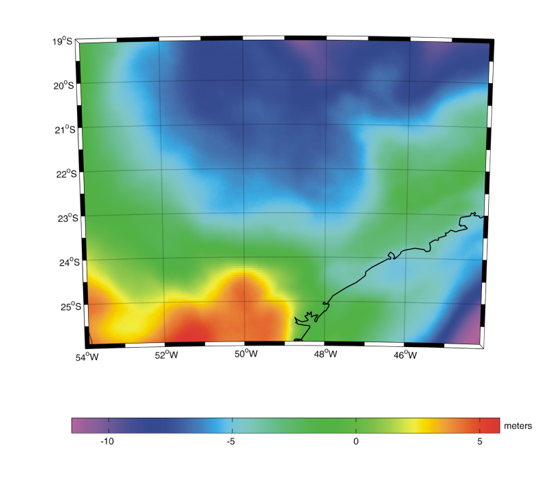
The GEOID-SP gravimetric models of the State of São Paulo, Brazil, have been computed by the remove-restore technique using two different methodologies: Stokes integration through Fast Fourier Transform (FFT) with spheroidal Molodenskii-Meissl kernel modification and Least Squares Collocation (LSC). The models are based on the same dataset of free-air gravity anomalies. The reference geopotential model is GO_CONS_GCF_2_DIR_R5 up to degree and order 200 for the FFT methodology, while GO_CONS_GCF_2_DIR_R3 up to degree and order 150 for LSC. The SAM3s_v2 DTM has been used for the computation of terrain correction and other topographic and atmospheric effects. The mean free-air gravity anomaly (FA) in a 5'x5' grid over continent has been derived from the complete Bouguer anomalies (FA over the ocean has been obtained from the DTU10 satellite gravity model). Geoidal heights, referred to the GRS80 ellipsoid, have been computed on a grid of 5'x5' covering the area from 17°S to 28°S in latitude and from 56°W to 42°W in longitude. The resulting models have been verified by comparing them with 363 GPS/leveling points distributed all over the area, showing differences with a root mean square of 0.22 m and 0.20 m for the FFT and LSC solutions, respectively. In the original file, data are stored in ASCII format, first column is longitude, second column is latitude, third column is geoid undulation.
Model Citations:
G.N. Guimarães, D. Blitzkow, R. Barzaghi, A.C.O.C. de Matos (2014). The gravimetric geoid of São Paulo State based on Fast Fourier Transform with modified Stokes kernel: GEOID-SP-2014-FFT. V. 1.0. GFZ Data Services. DOI: 10.5880/isg.2014.002
G.N. Guimarães, D. Blitzkow, R. Barzaghi, A.C.O.C. de Matos (2014). The gravimetric geoid of São Paulo State based on Least Squares Collocation: GEOID-SP-2014-LSC. V. 1.0. GFZ Data Services. DOI: 10.5880/isg.2014.003
Reference:
G.N. Guimarães, D. Blitzkow, R. Barzaghi, A.C.O.C. de Matos (2014). The Computation of the Geoid Model in the State
of Sao Paulo Using Two Methodologies and GOCE Models. Boletim de Ciencias Geodesicas (Online), vol. 20,
pp. 183-203. DOI: 10.1590/s1982-21702014000100012
Web of Science ID:
DRCI:DATA2023050026130236
Digital object identifier:
DOI: 10.5880/isg.2014.002 (FFT geoid in ISG format)
DOI: 10.5880/isg.2014.003
(LSC geoid in ISG format)
|